.png)
Emerald Isle, NC History
- Denis Raczkowski

- Apr 17, 2020
- 2 min read
Updated: Apr 18, 2020
Emerald Isle, which takes its name from the large maritime forests on the island is a town in Carteret County, North Carolina, It is part of the Crystal Coast and occupies the western half of Bogue Banks. This west end of Bogue Banks was originally home to nomadic Native Americans and, later, whalers. With the singular exception of a community called Middletown which fifteen families called home in the 1890’s, this western end of Bogue Banks remained mostly uninhabited until the 1950's, when small family cottages began to appear.
Several years after Atlantic Beach was developed as a seashore resort, Henry K. Fort of Philadelphia bought the land that now makes up most of Bogue Banks, including Emerald Isle along with 500 acres on the mainland, in what is now the town of Cape Carteret. Fort planned to link the island and his mainland properties with a bridge and develop a large resort. When support for constructing the bridge could not be raised, he abandoned the project.
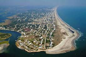
In 1951, seven individuals including William B. McLean and George F. Spell, pooled $350,000 to buy what was essentially the untamed and unnamed western 12 miles of Bogue Banks from Anita Maulick, Ford’s daughter. There were no piers, no grocery stores, and no roads that extended past Salter Path. Before development could commence, the area needed a name. A leading candidate was Gulf Stream Beach, until a consultant flew over the undeveloped land. The green, dense maritime forest in the blue water looked like a gem, and it’s been Emerald Isle ever since. Emerald Isle was sliced into thousand feet wide blocks extending from ocean to sound. The partners drew from a hat for the ownership of the 54 blocks. Because they wanted Emerald Isle to be family-oriented, the owners limited commercial and mobile/manufactured home development. Unbeknownst to McLean and his co-investors, they were creating the quintessential North Carolina beach town. This planning, rudimentary as it was, is what prevented Emerald Isle from becoming a hodgepodge like many other beach towns.
A ferry service was launched in 1960 and provided access from Cedar Point to the western end of modern-day Emerald Isle. That ferry, memorable for long lines of automobiles returning to the mainland on Sundays, was decommissioned in 1971 when the Cameron Langston Bridge opened. No longer did all materials need to be transported by ferry or by truck through Morehead City and down the island to Emerald Isle. The bridge also significantly increased visitor traffic and residential and commercial development in the town. Today, both the ocean and sound sides of Emerald Isle are populated with large and small homes and duplexes, along with a “downtown” commercial district. While there is a smattering of condominiums, there is only one oceanfront hotel. With recent zoning limiting new construction to a maximum height of 40 feet, that will remain the only hotel. Through insightful and visionary stewardship, modern day Emerald Isle has maintained the family-oriented atmosphere envisioned by the original investors.
To learn more about life in Emerald Isle, NC, my town of residence, go to my website, www.EIHomesforSale.com and request my free Guide to Living Were You Vacation or text your email address to: 919-308-2292. Stay well and stay safe.


Comments